the why
Enterprise-grade GIS data.Ready to use.Ready for insight.
Unlock reliable, up-to-date, globally consistent geospatial datasets with minimal prep and maximum impact.
Why your GIS efforts shouldn’t start with data chaos.
Too often, geospatial teams spend hours cleaning, stitching and normalising map layers. They juggle disparate data sources, struggle with inconsistent attribution, and then race to deliver insights before deadlines. With the HERE GIS Data Suite approach, you skip the prep phase and go straight to value.
Globally consistent, quarterly-refreshed data
Get a global foundational dataset with enterprise-grade accuracy — refreshed quarterly, so your insights always reflect the latest real-world reality.
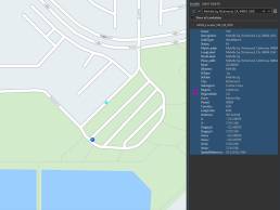
Network analyst-ready
The network dataset in HERE GIS Data Suite is preconfigured and built on HERE’s industry-leading map data, enabling precise analysis in ArcGIS Network Analyst for accurate routing, accessibility, and spatial optimization.
Pre-configured for ArcGIS workflows
Delivered in Esri-native formats, pre-configured and styled so your team can start working immediately with reliable, production-ready map data.
Flexible deployment & scalability
Whether you need regional data for a single project or global coverage across multiple sites, HERE GIS Data Suite scales effortlessly. Start small, expand seamlessly, and maintain consistent data quality everywhere.
Apply across your workflows
Enterprise-grade accuracy and consistency
Built from HERE’s trusted global map data, ensuring spatial alignment and reliability across regions and datasets.
Ready-to-use Esri-native formats
Delivered as feature classes, network datasets, and locators that plug directly into ArcGIS Pro and Enterprise environments.
Comprehensive attribution
Includes road restrictions, speed limits, tolls, POIs, and administrative boundaries to support complex spatial analyses.
Quarterly updates for current data
Maintain confidence in your outputs with regularly refreshed datasets reflecting real-world network changes.
Flexible licensing and deployment options
Choose regional or global coverage, scale to new geographies, and integrate seamlessly with existing GIS infrastructure.
Reduced data-prep workload
Spend less time cleaning and reconciling multiple sources, and more time delivering insights that drive decisions.
See it for yourself. Start turning data into insight.
Schedule a tailored demo and discover how your team can start using enterprise-ready GIS datasets today.
Questions? We’ve got answers. ↓
Because the datasets are pre-prepared and Esri-ready, your team can begin using them immediately.
Esri native formats, vector tiles, network datasets, locator files — ready for integration with your GIS workflows.
Yes — globally refreshed quarterly to keep pace with real-world changes.
Absolutely — flexible delivery means you can deploy for a specific project now and expand as your needs grow.
Built on 40 years of mapping expertise.
The data engine behind the solution draws on proven map-making technology and enterprise clients across industries and geographies.