the why
How we provide companies with the best Location Data
With recent developments in our increasingly data-driven world, like ‘Big Data’, it has become more and more important as a business to keep with the times and use data to your advantage. Using relevant and accurate datasets, your business can be streamlined and expanded.
Understanding Location Data
Location data refers to information that specifies the geographical position of a device or object. It is commonly generated by technologies such as GPS, Wi-Fi, Bluetooth, and cellular networks, and can be collected from devices like smartphones, vehicles, or IoT devices. This data typically includes coordinates (latitude and longitude) and may also encompass additional information such as altitude, direction, and speed. Location data is crucial for a variety of applications including navigation, mapping services, location-based advertising, and tracking the movement of goods and people. It enables services like ridesharing, fitness tracking, and emergency response systems to function effectively.
The use and sharing of location data raise important privacy concerns, as it can reveal sensitive information about an individual’s habits, preferences, and routines. Consequently, managing and protecting location data is a significant aspect of data privacy and security practices.

About our Location Data Services
At the heart of the Local Eyes business lies a deep expertise and passion for data. Our dedicated team of data experts meticulously leverages this information to craft innovative, data-driven solutions tailored to our clients’ needs. If your business is seeking a fully customized solution, Local Eyes is equipped to provide it using our extensive and diverse datasets.
We offer a broad spectrum of data, encompassing various categories to ensure we can address your specific requirements. Our data-driven approach enables us to create highly personalized solutions that align perfectly with your business objectives. We invite you to reach out to us to explore the vast possibilities available. Discover how our data can drive your business forward, enhance your decision-making processes, and ultimately contribute to your success. Contact us to discuss your needs and learn more about the extensive data services we offer.
The location data available includes but is not limited to the selection of categories listed below.
How the HERE platform boosts your company's performance
Decrease the cost of running your fleet by 20%
Reduce re-routing time by up to 90%
More Sustainable
What types of data are used for Location Intelligence?
Location Intelligence leverages all types of data sets – including internal business data and publicly available information. This could involve addresses, either in plain-text form or as latitudinal and longitudinal coordinates. While the former is more commonly used, the latter does have the advantage of being standardised. Address information can be inconsistent – so organisations may need location intelligent software that is capable of processing unstructured data in order to collate and analyse it.
Other forms of Location Intelligence data could include footfall, traffic density, census information, climate data, or consumer spending analysis. The particular form that your Location Intelligence will take is likely to depend on your specific business area and needs. As mentioned previously, businesses won’t necessarily have to collect all their Location Intelligence data from scratch themselves. Many well-known mapping tools use open data, which means they make information publicly available – so businesses are free to use it in their own Location Intelligence analysis.
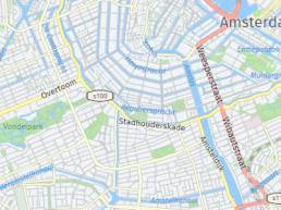
Maps
One of the cores of our partner HERE and our business is map data. As the biggest mapmaker in the world HERE provides highly accurate and up to date maps. These are divided into a large variety of different layers like streets, administrative boundaries and land usage. This way you’ll only have maps with information you are interested in, so no cluttered and impossible to read maps. These maps are of course updated regularly (quarterly) to ensure accuracy.
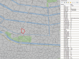
Geodemographics
Using the CBS dataset on key figures of all Dutch postal codes as a base, and enriching it using advanced analytical ‘big data’ tools, Local Eyes has come up with an enhanced, extended and complete dataset on numerous key figures of all six position postal code areas in the Netherlands. Among others these include: number of inhabitants, inhabitants by gender and age group, income, household type and attributes in the surrounding area like supermarkets, hospitals, restaurants, key infrastructure, etc.
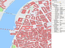
Land registry and Building data
This location dataset contains all major information on all individual properties in the Netherlands. This ranges from address to floor space and type of use (residential, office, etc.). The included features and information are fully customizable and can be specifically tailored to your needs. Don’t refrain from asking us about the possibilities for your use case. This dataset not only holds information on buildings but also includes all objects in the public space such as trees and streetlights.
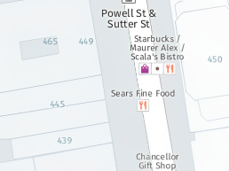
Geo Marketing and POI's
Together with partner HERE Technologies, Local Eyes has a very complete dataset of Points of Interest (POI’s) at its disposal. With the power of HERE Technologies, the biggest mapmaker in the world, this dataset is continuously kept up to date (quarterly) to make sure the information on the POI’s is as complete as possible. These POI’s are conveniently ordered in nearly 600 categories (grocery store, EV charging station, tourist attraction, etc.) to ensure maximum accuracy. This dataset is very customizable by for example adding information on floor space of individual POI’s.
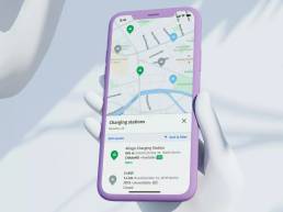
EV Charge Points
With the electrification of the vehicles on the road, the need for charging points has increased too. And with this the need for good mapping of these charging points has grown. Luckily Local Eyes together with its partner HERE has a very complete dataset on these charging points at its disposal. This dataset includes information on type of charging point, charge speed and availability of 500,000 EVSEs across 240,000 charging stations in 91 countries worldwide.
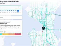
Traffic Analytics
Based on multiple different sources (vehicle sensor data, fixed sensor data, government sources and trillions of historical traffic records), this dataset ensures a very high accuracy in traffic analytics. Because of the very volatile nature of vehicle traffic, this dataset is updated daily. For even more frequent information on traffic in real time see the routing and traffic API’s under (Route Optimization). Either as a standalone or combined with our other datasets this dataset can provide a very useful insight when making informed decisions about future traffic management.
Which industries are using Location Data?
There are a huge number of businesses that stand to benefit from Location Data. Firstly, insurance firms use spatial data to be more proactive, using data analysts to write more accurate policies and offer policyholders more accurate premiums. Financial services, public sector bodies, retailers and higher education institutions are also frequently employing Location Data in some way.
It is also worth noting that, even within a single organisation, certain individuals may be more likely to use Location Data tools than others. Marketing teams, logistics operators, and technical staff make up those that will predominantly have direct contact with Location Data solutions. Even so, all employees could benefit from a greater understanding of the important role that location plays in meeting customer demands.
Location Data challenges
Acquiring, storing and managing Location Data is no easy task – which means that there are several challenges that organisations have to mitigate before they can start to discover the rich insights that Location Intelligence can deliver. We’ve listed some of the most common below:
Privacy
Long before the formalisation of GDPR rules in the EU, concerns around data privacy had been bubbling away. For any business wanting to collect location data pertaining to their customers, it is essential that they are open and honest about what that data will be used for. It’s also important to check regulatory standards in your respective market to ensure compliance.
Data Quality
It’s not enough to simply have lots of data – it needs to be of good quality. Standardisation is important here, as it will make it much easier to carry out analytics on your data. Remember to verify your data and eliminate inaccuracies – and don’t forget the importance of good data scientists to help ensure your data is of the highest quality.
Finding the Right Tool
There are a variety of analytics and mapping tools out there to help you with your Location Intelligence needs but some will be more relevant to your business than others. Don’t rush into choosing your LI tool – carefully assess its features and collect feedback from other users.
How Local Eyes can meet your Location Data needs
At Local Eyes, we have a wide range of datasets at our disposal. Part of this is thanks to our close partnership with HERE technologies, the biggest mapmaker in the world. Whatever your Location Data needs might be, we can provide you with the right solution and support.
If you are interested or have questions about how Local Eyes can help your business with Location Data, please don’t refrain from contacting us and we will provide you with more information, pricing and samples of the data we have to offer.