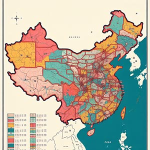
4- and 6-digit Postal Code Boundaries
Detailed geographic delineations of Chinese postal regions, providing a structured framework for accurate spatial analysis and operational efficiency. These boundaries enable precise location analysis, demographic studies, logistics planning, and targeted marketing, helping businesses and organizations optimize their strategies across various sectors. By defining postal code regions at both 4-digit and 6-digit levels, this dataset supports enhanced service area management, streamlined delivery routing, and improved customer segmentation.
Logistics and e-commerce companies can leverage this data to optimize distribution networks, reduce delivery times, and improve supply chain efficiency. Additionally, government agencies, market researchers, and urban planners can utilize these boundaries for infrastructure development, public service optimization, and resource allocation. By integrating high-resolution postal code boundaries into their operations, businesses can make data-driven decisions, enhance geographic targeting, and improve overall efficiency in the Chinese market.
Dataset Details
Need help choosing a dataset?
Contact us for more information:
Discover high-quality geospatial datasets tailored for professional use in logistics, mapping, and data analytics. Our catalog includes detailed location-based data by country, format, partner, and update frequency. All datasets are curated for accuracy, consistency, and usability across industries. Whether you’re building smart city applications or improving route planning, our data supports informed decision-making.
Browse by region or partner to find the dataset that fits your needs. Need help selecting the right format or version? Contact our team for expert guidance.
Trusted by businesses across Europe and beyond, our data solutions are built to scale.