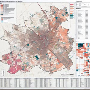
Insee Boundaries
Detailed geographic divisions established by the National Institute of Statistics and Economic Studies (INSEE), providing a comprehensive framework for analyzing population distribution, economic trends, and regional development in France. These boundaries play a crucial role in supporting demographic analysis, urban planning, resource allocation, and policy-making by offering precise spatial data that aids both public and private sector decision-making.
Local governments, businesses, and researchers rely on this dataset to assess socioeconomic patterns, optimize infrastructure projects, and improve service delivery. By leveraging INSEE boundaries, organizations can enhance strategic planning in areas such as transportation networks, housing development, and environmental management. These divisions also facilitate targeted marketing, electoral district planning, and statistical reporting, ensuring data-driven insights that contribute to efficient governance and sustainable growth across various regions.
Dataset Details
Need help choosing a dataset?
Contact us for more information:
Discover high-quality geospatial datasets tailored for professional use in logistics, mapping, and data analytics. Our catalog includes detailed location-based data by country, format, partner, and update frequency. All datasets are curated for accuracy, consistency, and usability across industries. Whether you’re building smart city applications or improving route planning, our data supports informed decision-making.
Browse by region or partner to find the dataset that fits your needs. Need help selecting the right format or version? Contact our team for expert guidance.
Trusted by businesses across Europe and beyond, our data solutions are built to scale.